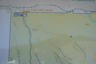
we departed early(ish) so that we could do the hike before it got too hot. i printed a map of the hiking trails, and jotted down the roads to get there. first navigational setback: missed the first turn about 3 miles from our house – went 5 miles past the road before i realized that we were heading in the wrong direction. oops. i blame hubby for allowing me to navigate to a new destination without double checking my route. he KNOWS i can’t read a map. at this point, you might wonder why i was so cavalier about not needing a compass – well, i don’t know how to use it, so it wouldn’t really help me if i got lost.
new shoes at the start of the hike:

we consulted the trail map in the parking lot - considered altering our planned route, and taking the trail to the right to see the giant fly... are we the only ones with a warped sense of humor?
we started down cronan ranch road, headed up west ridge trail and then looped back. i took some test pictures to see if i magically figured out how to use my camera this morning. i think i might try to read the instructions soon. maybe.
view up from the start of our hike: 

view from the top of the ridge... in the distance, you can see the lollipop tree (a local landmark above the river used by kayakers and rafters) - it is really just a tiny dot on the top of the hill from here:

hubby checking out the shrubbery on the side of the trail:
he said that it had signs of being poisonous: 3 leaves, red color, shiny appearance. that's why i married him... okay, not actually WHY i married him, but it is a great 'free with purchase' bonus gift.  on the way down the ridge trail, we could finally see the river:
for those living in the greater sacramento area, i would highly recommend this hiking area. no fee to park (we parked at the lot off of pedro hill road), and we didn’t see anyone the entire time we were hiking. we saw a hot air balloon operator in the parking lot at the start of our hike, and another hiker at the end, but other than that, did not cross paths with another human. i believe you can get down to the river (we didn’t) from the main trail. after our hike, we drove past the other parking area (off hwy 49), and it was full of horse trailers. so, watch your step on the trails – no need to get horse dung in your shoes just to break them in.


2 comments:
Nice blog! Where was your eagle scout hubby when I was rafting down the river and was thrown into a bush of poison oak huh??? :-)
Love the ten essentials!!! I can't believe he let you go with only 5 of them.
Post a Comment